
Budapest Metro, in Hungarian Budapesti metró, opened in 1896 to celebrate the Millennium of Hungary; it is the second oldest metro system in Europe after London. In 2002 the historical line M1 was declared a World Heritage Site.
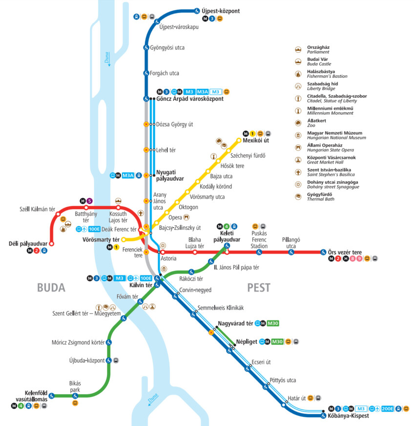
Attualmente la metropolitanda di Budapest è composta da quattro linee: M1 (gialla), M2 (rossa) e M3 (blu). La M4 (verde) è la più recente: il primo segmento ha aperto il 28 marzo 2014 ed è stata pesantemente criticata per i notevoli ritardi nei lavori, tuttora in corso.
The Budapest metro system is made up of four lines: M1 (yellow), M2 (red), and M3 (blu). M4 (green) is the newest line. Its first segment was opened on March 28th 2014, and the whole project was severely criticized for the severe delays in the works, which are now still in progress.
Line M5 is still under construction. It will connect Varga Jeno tér to Pomázi út, double crossing the Danube river and Margaret Island.
Below you can see the Budapest Metro map with the 4 lines and stops at the main sights in Budapest. Click on the map to enlarge it.

You can also download and print a map of Budapest’s metro lines in PDF format by clicking on the button below.
Metro Map in PDFAt the Deák tér station you will find the Underground Railway Museum, a museum area displaying historical carriages, photographies, and maps of the first continental railway system.
City Card allow you to save on public transport and / or on the entrances to the main tourist attractions.
